Quebrada el Pilon Riverbed Trail
- TICATOVE/ Angie
- Apr 8, 2021
- 1 min read
Updated: Jun 21, 2021

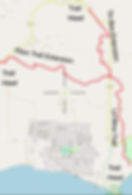
Quebrada el Pilon is an out and back hike that intersects with Quebrada la Mina Trail system. You can either start on the west side of the trail at St. Rd. 201 km 5.3 or start on the east side where it intersects with Quebrada la Mina under St. Rd. 996.


Park on the side of St. Rd 201 at Kilometer marker 5.3; ~1.5miles

Allow 1.5hr one way

Recommend sneakers or shoes with good tread that can get wet.

Flat slope with rocky, sandy and dirt path. Many rocks to clamber over.
Description from the Quebrada la Mina intersection:
Walk the Quebrada la Mina trail from the south trailhead for about one mile. At the underpass of St. Rd. 996 (approx 1 mi. of hiking), take the fork to the west. At another ~100 yards, look for a left turn to continue southwest. 1.5 miles to Rte. 201(km marker 5.3)
Description from St. Rd. 201 to the Quebrada la Mina intersection:
Look for the kilometer marker 5.3 on St. Rd. 201. Park off the road in the grass. Look for the trailhead on the southeast side of the road. Follow the trail to the la Mina intersection at the 996 underpass. If you turn north, you will end up at the culvert marking the exit to Tin Box. If you turn south, you will end up at the Cayo de Tierra access road.
Trail is located on land managed by the Puerto Rico Dept. of Nat. Resources
Post text, images and map by Greg Guckenburg
Distance Icon made by Pixel perfect from flaticon.com
Hourglass Icon made by Freepik from flaticon.com
Shoe Icon made by photo3idea_studio from flaticon.com
Effort Icon made by geotatah from flaticon.com


